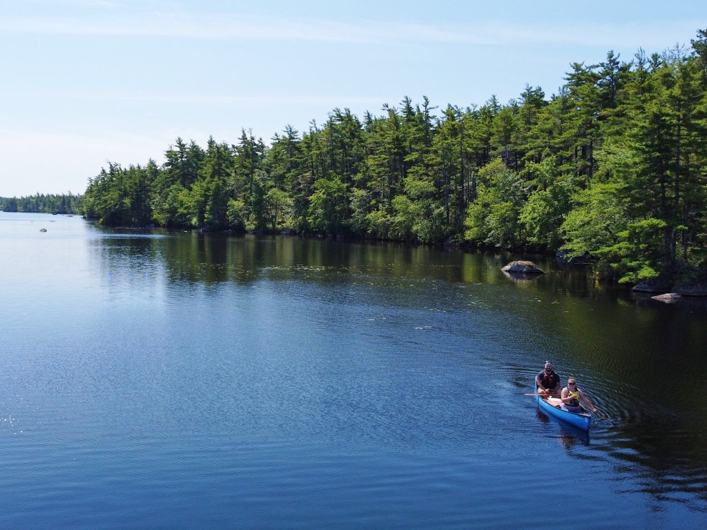
Kejimkujik National Park is one of the best places to go canoeing in Nova Scotia. If you’re planning to visit Keji, consider exploring the park by canoe. There are several different paddle routes and backcountry campsites to choose from. Whether you’re a seasoned canoeist or novice paddler, a multi-day Keji Southern Lakes adventure will not disappoint!

Last Updated: January 9, 2026
Growing up in Nova Scotia, I had the chance to visit Kejimkujik (pronounced Ked-juh-muh-koo-jik) a few times — but never stayed overnight. I was thrilled to finally plan a multi-day trip and head into Keji’s backcountry this summer. With many different lakes in the park, canoeing Keji’s flatwater can be a great family-friendly adventure. Whether you’re with a group or flying solo, I’d add canoeing Kejimkujik National Park to your list.
Update: Kejimkujik National Park’s backcountry reservations will launch on Wednesday, February 11, 2026 at 8:00am AT.
This post includes affiliate links. If you make a purchase through one of the links, I may receive a percentage of the sale at no extra cost to you. Thanks for your support!
Keji Southern Lakes Map
I was very impressed with the high-quality Keji backcountry map and wouldn’t paddle without one. While the map is waterproof, I used this SealLine map case for extra protection. While you can find the map online, I suggest buying a hard copy at the Parks Canada Visitor Centre.
About Keji Southern Lakes Canoeing
Location: Kejimkujik National Park, Nova Scotia
Distance: 48 km loop
Difficulty: Moderate
Time: 4 to 5 days
Campsites: 30, 40, 31
Lakes: George, Kejimkujik, North Cranberry, Puzzle, Cobrielle, Peskowesk, Hilchemakaar, Lower Silver, Back, Beaverskin, Peskawa, Mountain
Portages: A, B, C, D, E, F, G, H, I, J, K, L, N
Season: May 20 to October 30
Reservation: Yes, reservations and backcountry permit required.
Features: The Keji Southern Lakes canoe route features multiple freshwater lakes in the Nova Scotia interior. You’ll find sand beaches and glacial erratic rocks throughout the park, as well as 16 backcountry campsites to choose from (most accessible by canoe or kayak only).

Keji Southern Lakes FAQ

Q. Where is Kejimkujik National Park and National Historic Site located?
A. Kejimkujik National Park is found in the Nova Scotian interior, about a 2-hour drive west of Halifax. Find directions to the Keji Visitor Centre on Google Maps. Keji is actually one park in two locations, with Kejimkujik Seaside on the Atlantic coast about 30 mins from the town of Liverpool.
Q. How long is the Keji Southern Lakes route?
A. Keji Southern Lakes offers a 49-km loop that includes most of the portage and lake routes available. You can also create a custom route to match your skills and desired trip length.
Q. How difficult is the Keji Southern Lakes canoe route?
A. Canoeing in the Keji Southern Lakes region is not overly difficult or technical. The paddling is almost completely flatwater and classified as easy. However, strong winds create challenging waves on the larger Peskowesk and Peskwawa lakes, requiring strong paddling techniques. Further, the number of portages required for the full loop adds to the difficulty level. Overall, I would consider the Keji Southern Lakes loop a moderate (or intermediate) paddling adventure.
Q. How many portages are on the Keji Southern Lakes route?
A. The 49-km loop includes 13 different portages. However, there are 16 different portage routes in the Keji Southern Lakes region.
Q. What is the longest portage route in Keji Southern Lakes?
A. Portage E is the longest portage from Minards Bay to Mountain Lake (or vice versa) at 2.3 km one way. Though I suggest accessing this portage from Mountain Lake to avoid the steep incline from Minards Bay.
Q. How many days does Keji Southern Lakes take to complete?
A. I recommend at least four days to complete the Keji Southern Lakes loop, with plenty of time to enjoy the backcountry. Though experienced paddlers could complete this route in three days or so, those desiring a more relaxed pace may choose to paddle over five days.
Q. What advice would you give someone attempting Keji Southern Lakes?
While most of the paddling in Keji is on flat water, Keji Southern Lakes is not an easy canoe route. You’ll find multiple portages connecting two larger lakes to smaller lakes in the backcountry. You must be able to carry your canoe. Physical fitness and previous canoe tripping experience are important. Keji is an excellent place to learn canoe tripping and backcountry camping skills, but preparation is essential. If you’re looking for a fun backcountry adventure, this could be for you!

Kejimkujik National Park History

Did you know Kejimkujik isn’t just a national park? In 1995, Keji was also designated a National Historical Site because of over 4000 years of Mi’kmaq occupancy. Interestingly, Kejimkujik is the first national park to gain this dual status. Many of the portage and canoe routes were established by the Mi’kmaq First Nation and continue to be used today. You can also find petroglyphs (rock carvings) and other cultural landscapes that highlight the importance of the area for the Mi’kmaw peoples.
Read next: Your Complete Guide to the Bowron Lake Canoe Circuit

Keji Southern Lakes Distances

Here are the approximate paddle distances for this Keji Southern Lakes route.
| KM | Location | Description |
|---|---|---|
| 0 | Eel Weir/Mersey River Bridge | |
| 16 | Site 30 – Lower Silver Lake | 2 tent pads, outhouse toilet, fire pit, bear hang |
| 30 | Site 40 – Peskawa Lake | 2 tent pads, outhouse toilet, fire pit, bear hang |
| 39 | Site 31 – Peskowesk Lake | 2 tent pads, outhouse toilet, fire pit, bear hang |
| 48 | Eel Weir/Mersey River Bridge |
Here are the portage distances for Keji Southern Lakes. Portages M, O, and P are not required for this canoe route.
| Portage | Length (km) | Description |
|---|---|---|
| A | 1.2 | Dry, rolling terrain. Canoe rest provided. |
| B | 0.12 | Over low ridge. Crosses the Fire Tower Rd. |
| C | 0.4 | Over a gradual rise. Short, steep section at Cobrielle Lake end. |
| D | 0.64 | Dry, rolling terrain. Canoe rest provided. |
| E | 2.3 | Longest portage. Steep climb from Minards Bay to Fire Tower Rd. Canoe rests provided. |
| F | 0.62 | Over rolling terrain. Canoe rest provided. |
| G | 0.8 | Peskowesk end of this carry is hidden in a cove. Canoe rests provided. |
| H | 0.2 | Over low ridge. |
| I | 0.2 | Over low ridge. |
| J | 1.2 | Follows Liberty Lake Trail for some distance. Canoe rests provided. |
| K | 0.4 | Steep climb from Peskowesk Lake. |
| L | 0.4 | Fairly level terrain. |
| M | 0.2 | Over low ridge. Canoe rest provided. |
| N | 0.8 | Two separate carries. One short carry around bridge, the other longer over gentle, sloping terrain. Rocky area. Canoe rest provided. |
| O | 0.8 | Gently sloping terrain. Canoe rest provided. |
| P | 0.2 | Gently sloping terrain. |
If you’re looking for more information on paddling distances, check out Friends of Keji Canoeing Distance Tables to plan your canoe trip (helpful resource!).

Directions to Kejimkujik National Park

Kejimkujik National Park is located in the Nova Scotia interior, not too far from the village of Caledonia and about 166 km from Halifax. If you’re coming from Halifax, take Highway 103 through Mahone Bay and then turn right onto Highway 8 in South Brookfield. Continue through Kempt to find the park entrance on your left. Find directions on Google Maps.
Tip: Kejimkujik National Park has two different locations in Nova Scotia. For this trip, head to Kejimkujik National Park and National Historic Site (not Kejimkujik Seaside).
Finding the Boat Launch

For this canoe route, start at the Eel Weir parking area beside the Mersey River bridge. From the park entrance, drive about 11 km on the Kejimkujik Main Parkway until reaching a parking area, past the turn-off to Jakes Landing. Continue down Eel Weir Rd for 8 km until the bridge. This is where the road ends. The boat launch is to the right of the bridge. You’ll also find picnic tables, an outhouse toilet, and a parking lot for your vehicle. This drive takes about 30 minutes from the visitor centre.
Read next: Your Complete Guide to the Bagwa Canoe Route in Saskatchewan
Keji Reservations — Backcountry Camping Options

Kejimkujik backcountry camping has grown in popularity over the past few years. If you’re planning a Keji canoe trip, book your sites early to avoid disappointment. I reserved all of my backcountry campsites as soon as reservations opened in February, yet was still unable to snag an island site…. Luckily, plan B worked out!
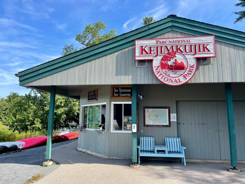
Book Keji backcountry sites through Parks Canada’s online reservation system or by calling 1-877-RESERVE (1-877-737-3783). When you arrive at Keji, you must register at the Visitor Centre and return your permit at the end of your trip.
Note: Keji reservations are scheduled to open on Wednesday, February 11, 2026 at 8:00am AT. Don’t wait too long to book your campsites. Plan the sites you want and have a few different route options in mind.

Where to Stay Near Kejimkujik National Park (Before & After Your Trip)
I stayed at Jeremy’s Bay Campground inside Kejimkujik National Park, which was a perfect base before and after paddling the Southern Lakes. If you prefer a comfortable bed before or after your canoe trip, Annapolis Royal is a convenient place to stay nearby. It’s close enough for an easy drive and makes a great base for restaurants, cafés, and supplies.
Thank you to Parks Canada for supporting this backcountry adventure by providing a complimentary night at Jeremy’s Bay Campground, along with a backcountry map and drone permit for filming.

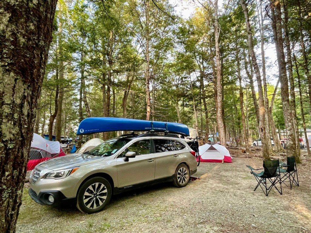
Canoe Rentals and Shuttles
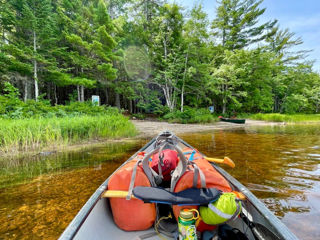
Don’t have your own canoe? No problem! Whynot Adventure provides canoe and gear rentals right in Kejimkujik National Park. We brought our own boat but rented a couple 70-litre MEC dry packs. It was easy, and these packs made portaging much more manageable. You can book your rental online and pick up gear at Jakes Landing. Many visitors plan one or two-night canoe trips, so reserving in advance is the best option in peak season.
If you’re bringing one vehicle and need a shuttle, arrange with Whynot Adventure in advance. We didn’t require a shuttle as we returned to Eel Weir, but it might be needed if you start at Jakes Landing and finish at Eel Weir (or vice versa).
Read next: Your Complete Guide to Fishing Cove Trail in Cape Breton

Keji Southern Lakes Canoe Itineraries (2–4 Days)

We chose to paddle Keji Southern Lakes for 4 days and 3 nights. There are shorter route options, though this full loop allowed us to experience a lot of Keji’s backcountry. Depending on campsite availability, you can spend as much or as little time as you’d like.
Here is my recommended 4-day paddle (loop) in Keji Southern Lakes:
Day 1 — Eel Weir to Lower Silver Lake (Site 30) – 17 KM
Day 2 — Lower Silver Lake to Peskawa Lake (Site 40) – 13 KM
Day 3 — Peskawa Lake to Peskowesk Lake (Site 31) – 9 KM
Day 4 — Peskowesk Lake to Eel Weir – 10 KM
Curious to learn more? Check out the full trip report or watch the video to get a feel for what Keji Southern Lakes is really like.
Here are some more Keji Southern Lakes itineraries:
2-day paddle (beginner)
Day 1 — Eel Weir to Cobrielle Lake (Site 27 or 26)
Day 2 — Cobrielle Lake to Eel Weir (via Mountain Lake)
Start at Eel Weir, paddle up to Minards Bay, and take Portage A onto North Cranberry Lake. Then take Portage B onto Puzzle Lake and Portage C onto Cobrielle Lake. Camp at site 27 or 26. The next day, paddle up Mountain Lake and take the 2.3-km Portage E back to Minards Bay, and then paddle back to Eel Weir.
2-day paddle (challenge)
Day 1 — Eel Weir to Lower Silver Lake (Site 30)
Day 2 — Lower Silver Lake to Eel Weir
Start at Eel Weir, paddle up to Minards Bay, and take Portage A onto North Cranberry Lake. Then take Portage B onto Puzzle Lake, Portage C onto Cobrielle Lake, Portage D onto Peskowesk Lake, and Portage G onto Hitchemakaar Lake. Take the short Portage H to reach Campsite 30 at Lower Silver Lake. On day two, take Portage I followed by Portage J back onto Peskowesk. Finally, take Portage F and then Portage E to Minards Bay and then paddle back to Eel Weir.
3-day paddle (challenge)
Day 1 — Eel Weir to Lower Silver Lake (Site 30)
Day 2 — Lower Silver Lake to Peskawa Lake (Site 40 or 38)
Day 3 — Peskawa Lake to Eel Weir
Start at Eel Weir, paddle up to Minards Bay, and take Portage A onto North Cranberry Lake. Then take Portage B onto Puzzle Lake, Portage C onto Cobrielle Lake, Portage D onto Peskowesk Lake, and Portage G onto Hitchemakaar Lake. Take the short Portage H to reach Campsite 30 at Lower Silver Lake. The next day, take Portage I followed by Portage J back onto Peskowesk Lake and then the short Portage K and Portage L onto Peskawa Lake. Camp at site 40 or 38. On day three, take Portage N onto Peskowesk and paddle down the lake to Portage F. Take Portage F and then Portage E onto Minards Bay and then paddle to Eel Weir.
3-day paddle (islands)
Day 1 — Eel Weir to Peskowesk Lake (Site 29)
Day 2 — Site 29 to Île de l’Orignal (Site 32)
Day 3 — Île de l’Orignal to Eel Weir
Start at Eel Weir, paddle up to Minards Bay, and take Portage A onto North Cranberry Lake. Then take Portage B onto Puzzle Lake, Portage C onto Cobrielle Lake, and Portage D onto Peskowesk Lake. Camp at Campsite 29. The next day, paddle up Peskowesk Lake and camp at Île de l’Orignal. Finally, take Portage F and then Portage E back to Minards Bay and paddle to Eel Weir on day three.

Keji Canoe Trip Packing List

Camping Gear
- Tent
- Groundsheet
- Sleeping pad
- Sleeping bag
- Sleeping bag liner
- Hammocks
- Siltarp
- Rain jacket
- Gravity water filter
- Water bottle
- Food / snacks
- Headlamp
- Bug spray
- Sunscreen
- Matches
- Jetboil stove & fuel
- Bowl
- Spoon
- Knife
- Biodegradable soap & scrub
- Toothbrush / toothpaste
- Toilet paper
- Towel
- Map / compass
- Sat comm device
- Powerbank / charger cables
- 2 70-litre dry bags
- 2 10-litre dry bags
- Sunglasses
- Binoculars
- Book
- First aid kit
- Down jacket
- Bear spray
- Car key
- Camera
- Clothing
- Water shoes
- Camp shoes
Canoe Gear
- PFD / life jacket
- Paddles
- An extra paddle
- Painter chord
- Bilge pump
- Throw bag
- Whistle
- Pilot knife (attached to PFD)
- Waterproof flashlight
- Yoke pad

Backcountry Meals in Kejimkujik National Park

Our meal plan was relatively straightforward. For breakfast, we alternate between instant oatmeal and instant potatoes with bacon bits and cheese. Lunches were generally something easy like wraps with peanut butter, honey, hummus, or whatever else we wanted. Beef jerky is a good pick-me-up in the middle of the day, too. Then for supper, we’d tend to have freeze-dried meals for the convenience factor (though I’d like to start dehydrating my own meals). Of course, we bring chocolate and other snacks, too. What do you eat in the backcountry?
Keji Backcountry Campgrounds are very well-equipped with bear hangs. Use the pulley system to keep your food up high and away from your tent. We use a dry bag to keep everything nice and dry.
Toilets in Kejimkujik National Park

Each backcountry campsite in Keji has an outhouse toilet. Though if nature calls elsewhere, dig a hole about six inches deep and 70 steps away from water sources, trails, and campsites. Pack out any toilet paper or bring it to the outhouse at your campsite.
Read next: Your Complete Guide to Canoeing the Yukon River

Backcountry Camping in the Rain (Keji Southern Lakes)

We got really lucky on this trip — it only rained on our last day! In Nova Scotia, the weather can change on a dime, so it’s always best to bring a lightweight tarp with you. Similarly, a rain jacket and waterproof pants will help keep you warm, dry and happy when inclement weather rolls in.
Read next: 3-Day Milk River Canoe Trip in Alberta — The Ultimate Guide

Backcountry Safety in Kejimkujik National Park

Wind and waves can make paddling on the larger lakes quite difficult. Depending on the conditions, you may need to extend your stay until the weather clears. Be prepared to add additional time to your trip. Further, paddlers should have canoe and navigation skills before attempting this route.
Bring and wear your personal floatation device (PFD). Make sure your canoe is equipped with necessary safety equipment, including a signalling device (whistle), throw rope bag, painter rope, bilge pump, and an extra paddle. These are all required by Transport Canada.
Have you taken a wilderness first aid course? Emergency rescues are not always easy or timely in the backcountry. I highly suggest learning wilderness first aid and bringing a first aid kit on your trip.
Tip: Always leave your trip plan with someone you trust. This should include when and where you’re going (including campsites) and when you plan to return. Bringing a satellite communications device can allow you to communicate with your contact if your trip plans change.

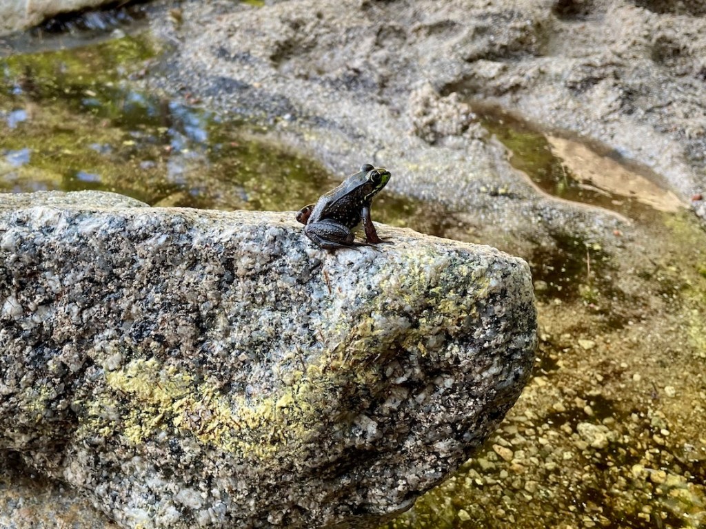
Wildlife in Kejimkujik National Park

We are visitors in the backcountry. If you’re lucky, you’ll see several different kinds of wildlife and enjoy the beauty in the wilderness. We saw an eagle and more loons than I can count, plus several other creatures. Remember, never feed wildlife and give them lots of space.
Kejimkujik National Park is bear country. Black bears roam freely and are generally afraid of humans. However, they will also take opportunities to eat human food from garbages or messy campsites. Once their natural human fear fades, they continue to seek out food in backpacks, coolers, etc. These bears are often terminated due to human mistakes. Keep all of your food and trash stored properly and help keep bears and other wildlife wild. Not a bad idea to carry bear spray, just in case.
Read next: Balancing Rock Trail: Natural Attraction in Nova Scotia

Keji Southern Lakes Canoe Trip Video
Are you planning a canoe trip to Kejimkujik National Park? Did you find this guide useful? Let me know in the comments below.
Save this for later? Hover over the image to add to Pinterest 👇

Thomas Coldwell has always been fond of the outdoors. He loves hiking, paddling, and camping, and thoroughly enjoys creating outdoor adventure resources for people like you. Originally from Nova Scotia, Thomas has lived in four Canadian provinces (NS, NB, ON, AB) and has travelled in 20 countries and counting.