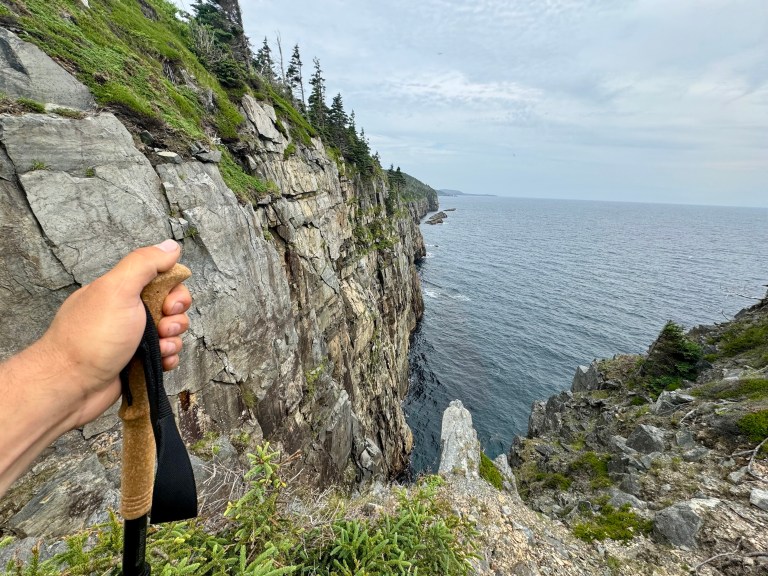
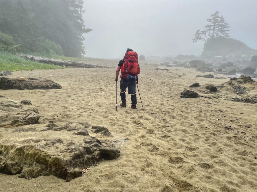
Backpacking the West Coast Trail was an unforgettable experience. This iconic 75-kilometre coastal trek on Vancouver Island exceeded my expectations, with dramatic scenery and some of the best tenting I’ve experienced on a multi-day hike. While it’s a demanding trail and not for everyone, it’s absolutely worth it for those looking for one of Canada’s most rewarding backpacking adventures.

Last Updated: January 25, 2026
The West Coast Trail is a 75-kilometre, multi-day backpacking route in Pacific Rim National Park Reserve, stretching through the traditional territory of the Huuay-aht, Ditidaht, and Pacheedaht First Nations. The trail follows historic walking and paddling routes established by Indigenous communities and was later developed to help rescue shipwreck survivors along the Juan de Fuca Strait. Over 7,500 people hike the West Coast Trail each year.
This iconic route had been on my bucket list for years, and this season I finally took the leap. My friend Kevin and I were lucky enough to secure coveted mid-July permits. This post shares some of our day-by-day experiences on the trail.
If you’re looking for practical advice on planning your first hike, be sure to check out this guide 👉 Your Complete Guide to the West Coast Trail on Vancouver Island
This post includes affiliate links. If you make a purchase through one of the links, I may receive a percentage of the sale at no extra cost to you.
West Coast Trail Map
About the West Coast Trail on Vancouver Island

Location: Pacific Rim National Park Reserve
Distance: 75 km point to point
Difficulty: Difficult
Elevation gain: ~230 metres
Time: 7 days / 6 nights
Dog-friendly: No. Only service animals are permitted.
Features: The West Coast Trail is a stunning coastal route with well-maintained campgrounds spaced along the way. Hikers can expect dramatic ocean views, frequent wildlife sightings, and historic lighthouses at Pachena Bay and Carmanah Point. That being said, this trail is highly technical, featuring more than 100 ladders, slippery boardwalks, roughly 130 bridges, frequent river crossings, and four cable cars.

Getting to the West Coast Trail

Kevin and I flew from Calgary to Victoria with full packs (I brought my Osprey Kestrel 68) and spent the night before catching the early morning West Coast Trail Express shuttle. The shuttle departs Victoria at 6:30am sharp and arrives in Pachena Bay around 12:30pm.
The 6.5-hour ride was long and bumpy, but absolutely worth it. If you’re planning to take the shuttle, I’d recommend booking well in advance to make sure you get a seat.

Where To Stay Near the West Coast Trail (Before & After Your Hike)

For the West Coast Trail, where you stay often depends on where you’re starting or finishing your hike. If you’re beginning at Pachena Bay, staying near Bamfield can make for an easy start, while Port Renfrew works well if you’re ending at Gordon River. Or, you can do what I did and stay in Victoria, which offers far more choice when it comes to accommodations and places to eat.

Our 7-Day, 6-Night West Coast Trail Itinerary

Before arriving at the trail, we agreed on an itinerary for our 7-day trip. Itineraries depend on the availability of permits (they book fast!) and the starting point. We planned to hike from Pachena Bay (near Bamfield) in the north to Gordon River (near Port Renfrew) in the south. For first-timers, I would highly recommend north to south.
Day 1: Pachena Bay to Michigan Creek (KM0 to KM12)
Day 2: Michigan Creek to Tsusiat Falls (KM12 to KM25)
Day 3: Tsusiat Falls to Cribs Creek (KM25 to KM41)
Day 4: Cribs Creek to Walbran Creek (KM41.5 to KM53)
Day 5: Walbran Creek to Camper Bay (KM53 to KM62)
Day 6: Camper Bay to Thrasher Cove (KM62 to KM70)
Day 7: Thrasher Cove to Gordon River (KM70 to KM75)
Read next: Rockcut Twillingate Trails: Coastal Hiking in Newfoundland

Pachena Bay to Michigan Creek — KM0 to KM12

After arriving at Pachena Bay, we checked in at the Parks Canada office and completed a COVID-19 self-assessment. I also picked up a small West Coast Trail sticker from the gift shop (woo!), which may have been a little premature since we hadn’t finished the trail yet… but I went for it anyway. 😉
In a typical year, mandatory orientation sessions at Pachena Bay and Gordon River are held at 10am and 2pm. During our hike, orientations were staggered as groups arrived between 9am and 3pm, and we were also required to watch a short video presentation ahead of time. We finally stepped onto the West Coast Trail around 3:30pm.
It was a short walk along the beach, and then we entered the forest where we’d spend most of the day. We navigated a few small ladders along the way. We stopped briefly at Sea Lion Haul Out Rock (KM 9) to watch the massive sea lions, and I caught a glimpse of Pachena Point Lighthouse, though the grounds were closed due to COVID-19.
After roughly three hours, and 12 km from the trailhead, we arrived at Michigan Creek Campground and settled in for the night. Kevin also introduced a daily tradition he calls “beefs and bouquets” (or from my camp days, “mountain highs” and “valley lows”) as a way to reflect on the day. You guessed it, the sea lions were my bouquet!


Michigan Creek to Tsusiat Falls — KM12 to KM25

My first night sleeping on the beach was surprisingly restful. After a hearty oatmeal breakfast, we packed up and hit the trail around 9:15am. One of our best wildlife sightings came just past the campground, where a black bear was feasting on mussels and crabs along the shore. I could barely contain my excitement while snapping a few photos. Kevin gave a loud “Hey, bear!” and it darted toward the forest, though not very far. Once we passed, it returned to its beachside breakfast like nothing had happened.
The roughly 13-kilometre stretch from Michigan Creek to Tsuisiat Falls includes a mix of beach walking and forest travel, with ladders, bridges, boardwalks, and the cable car crossing over the Klanawa River. Somewhere along the way, a series of unfortunate events resulted in one of my trekking poles snapping clean in half. Thankfully, a bit of creative problem-solving and a tent pole splint brought it back to life. Turns out they have more than one use.
Tsusiat Falls is a very popular campground, and during our hike, Parks Canada had limited stays to one night to help reduce crowding. Even so, it didn’t feel overly busy thanks to the long, open beach. We arrived around 3:00pm after about 5.5 hours on the trail, including a long lunch break at Nitinaht Narrows. The evening was chilly and damp, but cozy. I spent it tucked under my siltarp, wrapped in my down jacket, with a hot drink in hand.
Read next: 4-Day Long Range Traverse Hike in Gros Morne National Park


Tsusiat Falls to Cribs Creek — KM25 to KM41.5

After another oatmeal breakfast, we set out around 10:00am for the 16-kilometre stretch from Tsusiat Falls to Cribs Creek. This would be our longest hiking day of the trip, but it’s nicely broken up by a stop at Nitinaht Narrows and the ever-tempting Crab Shack. By 12:30pm, I was eating fresh salmon with a baked potato, followed by a few chocolate bars for dessert. Worth every step. The West Coast Trail hiking permit covers the water taxi crossing at Nitinaht Narrows, which makes this mid-day break feel especially satisfying.
We wrapped up lunch and our rest around 2:00pm and continued on, moving between boardwalks and beach before heading back into the forest ahead of Dare Beach due to high tide. At one point, we missed a beach access ladder and ran straight into an impassable headland, but thankfully only had to backtrack about 50 metres. The forest section that followed was seriously overgrown, with what felt like a couple of kilometres of bushwhacking. The final half-kilometre of beach, though, was a joyful stroll and a welcome lead-in to camp.
Cribs Creek has some of the best campsites on the trail. The sun was still high, there wasn’t a single tent tucked into the forest (aside from Kevin’s hammock), and tent flies were drying while spirits were rising. One of the coolest features here is the rock shelf just offshore, where waves spill over the edge and create a small, cascading waterfall. A pretty great place to call home for the night.


Cribs Creek to Walbran Creek — KM41.5 to KM53

Thick fog rolled in off the ocean as we left Cribs Creek behind. Much of the day was spent walking along the beach, with a short detour through the grounds of Carmanah Point Lighthouse. The lighthouse was built in 1922 to replace the original structure from 1891. While both Pachena and Carmanah lighthouses were closed to the public at the time due to COVID-19, hikers were still allowed to pass through the grounds without lingering. Lightkeepers may no longer be watching for shipwreck survivors, but they remain an important support for thousands of hikers each year, including those who need emergency assistance.
The 12-kilometre stretch from Cribs Creek to Walbran Creek Campground took us from about 9:00am until 3:00pm. It’s well worth stopping at Bonilla Point to check out the waterfall along the way. This section often requires cable car crossings at Carmanah and Walbran Creeks, though we were lucky enough to hop across the low water levels instead. A swim at Walbran Creek capped off the day and was easily one of my favourites!
Read next: 2-Day Glacier Lake Hike in Banff National Park


Walbran Creek to Camper Bay — KM53 to KM62

“Who’s ready for some tough ladder climbing?” The stretch between Walbran Creek and Camper Bay is entirely forested and packed with major ladder sections that drop into, and climb out of, deep gorges. Many people consider this the most difficult part of the trail, and it’s easy to see why. It demands both fitness and confidence. I couldn’t help but wonder how this route was managed before the ladders existed.
Our 9-kilometre day started around 9:30am and wrapped up close to 2:00pm. I don’t mind ladders, but I was still relieved to reach the Logan Creek Suspension Bridge, which spans 113 metres and hangs about 40 metres above the creek below. Crossing the bridge means you can skip a big ladder descent and climb here, though there are still plenty more ahead. Cullite and Sandstone Creeks both deliver, and Cullite in particular stands out, with the highest concentration of ladders on the trail: seven on one side and eleven on the other.
Camper Bay is tucked into a small cove with limited ocean views. The sun dipped behind the trees early, making for a cool and windy evening. Out came the down jacket and, once again, a mug of hot tea.


Camper Bay to Thrasher Cove — KM62 to KM70

There’s a lot to love about the 8-kilometre stretch between Camper Bay and Thrasher Cove. Chief among them is Owen Point, a well-known stop for exploring sea caves when the tides cooperate. We lingered at Camper Bay until about 11:30am, waiting for the tide to drop before heading out. If the tide is too high, Owen Point isn’t passable, and you’ll miss one of the most spectacular sections of the trail. For first-timers especially, timing the tides to take this scenic beach route is well worth it. From Camper Bay, it took us roughly two hours to reach Owen Point.
One of my favourite moments of the entire trip happened along this stretch: watching a bald eagle calmly eat a fish off a piece of driftwood, completely unfazed by our presence. I stood there filming for a solid seven minutes. By the time we reached Owen Point, the tide still wasn’t quite low enough to pass, so we settled in for lunch while watching seals bob just offshore. Easily the best kind of dinner-and-a-show.
Then there’s a section affectionately known as The Boulders. For about an hour, we hopped and climbed over rocks bigger than cars (or at least smart cars). It’s often recommended to budget up to two hours here, as these boulders can become extremely treacherous when wet or even slightly damp. We lucked out with dry and sunny conditions, which made a big difference.
We arrived at Thrasher Cove shortly after 4:00pm. This is the first campsite for hikers starting at the Gordon River or Port Renfrew trailhead, and the last for those beginning at Pachena Bay, which makes it a popular spot. As the tide came in, the beach shrank noticeably, with several tents creeping closer to the water. Even so, it felt like a fitting place to spend our final night on the WCT.
Read next: Your Complete Guide to Thru-Hiking the East Coast Trail


Thrasher Cove to Gordon River — KM70 to KM75

When we started our journey back at Pachena Bay, Parks Canada staff suggested budgeting one hour per kilometre for the final 6-kilometre stretch. Right after Thrasher Cove, the trail climbs steeply for about a kilometre, rising to roughly 230 metres, the highest point on the West Coast Trail. Kevin and I set off around 7:00am with a goal of reaching Pacheedaht Campground by noon. Our flight out of Victoria wasn’t until 5:00pm, but we didn’t want to cut it close.
We pushed through that first steep kilometre and then continued with the familiar rhythm of ups and downs through the forest. By just before 10:00am, we reached the final ladder. In under three hours, we’d completed the home stretch (woo!). The Gordon River Ferry runs every hour on the half-hour, as long as you remember to raise the buoy, and we crossed at 10:30am on our way to Port Renfrew.
Pacheedaht marks the southern trailhead for hikers travelling south to north. There’s a Parks Canada office here, along with a small store stocked with candy and snacks. Best of all, there are coin-operated showers. You’re welcome to the person who ended up sitting next to me on the plane.
I didn’t feel quite done with the WCT. Maybe that’s the best way for a trip like this to finish. Some people say the best part of the WCT is finishing it, but I’m not sure I agree. While it felt good to complete my longest backpacking trip to date, what stayed with me more was everything the trail offered along the way. Sharing the experience with my buddy Kevin made it even better. Thanks for being part of it!


Know Before You Go

Even experienced hikers can find the West Coast Trail challenging, especially when you factor in technical terrain and unpredictable weather. Each season, more than 100 emergency evacuations take place along the trail, and during our seven-day hike, we learned of at least two helicopter rescues after the fact.
All of this is to say: take an honest look at your skills, experience, and comfort level before committing to the WCT adventure. When the timing is right and you’re well prepared, it has the potential to be a truly unforgettable experience!
Note: Parks Canada and the West Coast Trail Guardians do an incredible job maintaining this expansive trail. That said, there are sections with rotted boardwalks, damaged bridges, and missing ladder rungs. When conditions are less than ideal, move carefully and proceed with caution on all technical sections of the trail.

West Coast Trail Video
Are you planning to hike the West Coast Trail? Have you already completed your adventure? I’d love to hear! Leave a comment below.
Save this for later? Hover over the image to add to Pinterest 👇

Thomas Coldwell has always been fond of the outdoors. He loves hiking, paddling, and camping, and thoroughly enjoys creating outdoor adventure resources for people like you. Originally from Nova Scotia, Thomas has lived in four Canadian provinces (NS, NB, ON, AB) and has travelled in 20 countries and counting.