
If you’re visiting Ottawa, add some Gatineau Park hiking trails to your itinerary. Just 30 minutes from the city, Wolf Trail is an ideal choice for an afternoon hike. This forested hiking trail offers a quiet escape, with the chance to spot wildlife along the way and enjoy several scenic lookouts. Beyond hiking, Gatineau Park also offers biking and swimming options, making it an easy outdoor add-on to any Ottawa trip.

Last Updated: February 2026
Gatineau Park, managed by the National Capital Commission, is a 361-km² park often claimed by Ottawa, though it actually sits across the river in Quebec’s Outaouais region. With more than 183 kilometres of trails, there’s no shortage of places to explore.
When I lived in Ottawa years ago, I spent time canoeing and swimming at Meech Lake, but hadn’t experienced much of Gatineau’s trail network. After a work trip and a tip from a friend, I laced up. It was surprising to find a quiet trail on this sunny Friday afternoon!
This post includes affiliate links. If you make a purchase through one of the links, I may receive a percentage of the sale at no extra cost to you.
Wolf Trail Map (Gatineau Park)
About Wolf Trail #62

Location: Gatineau Park, Quebec
Distance: 8.5 km loop
Difficulty: Moderate
Elevation: 290 m elevation gain
Time: 2.5 – 3 hours
Dog-friendly: Yes, but dogs must remain on a leash.
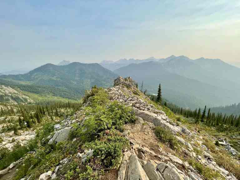
Features: Wolf Trail (#62) is a forested loop in the Gatineau Hills featuring two standout viewpoints. Tawadina Lookout offers sweeping views over the Ottawa River Valley, while Mahingan Lookout looks out across the Gatineau Hills. There are benches along the way for well-earned breaks. Also known as Trail 62 or the Blanchet Trail, this route is one of the best hikes in Gatineau Park (no matter which name you use).

Gatineau Park Parking & Access

Compared to some parks, parking in Gatineau Park is fairly straightforward. The Wolf Trail (#62) trailhead is accessed from the P13 parking lot, which is easy to find. From Ottawa, cross into Gatineau and take Autoroute 5 north to Exit 12 for Old Chelsea Road. From there, follow Chemin du Lac Meech for about 9 km until you reach P13 on the left.
There’s no entrance fee for Gatineau Park, but parking is paid during the summer months. From mid-June through Labour Day, expect to pay for parking at many popular lots, including those around Meech Lake (like P13). You can either pay a daily rate or purchase a seasonal parking pass, depending on how often you plan to visit. Parking rates and pass options change annually, so it’s best to check the NCC website before heading out.
Read next: King Mountain Hike in Gatineau Park in Quebec

Wolf Trail Hike — A Popular Gatineau Park Trail

You never know what spring will bring in Canada. I visited Ottawa in May 2022 and decided to squeeze in an afternoon hike in Gatineau Park, only to be met with one of the hottest days of the year so far (temperatures climbing above 30°C). Thankfully, I brought the right gear and enough water to stay comfortable. I was a bit hot and sweaty along the way!
Wolf Trail (#62) begins at the P13 parking lot near Blanchet Beach. From the lot, head uphill past the info sign and onto a shaded forest trail. About 500 metres in, you’ll reach a fork where I kept left and hiked the loop clockwise. It’s less steep than counterclockwise. After roughly 3 km, a short side trail leads to Tawadina Lookout with beautiful views over the Ottawa River Valley (don’t miss it). A perfect spot for a break or picnic. From there, continue uphill for another 1.5 km to Mahingan Lookout before following the mostly downhill trail back to the parking lot. The full loop is 8.5 km and typically takes 2.5 to 3 hours, making this a great option if you’re looking for a Gatineau Park hike with rewarding views.
Note: If you’d like to extend your stay, summer and winter camping are available in Gatineau Park. You must make a reservation to camp in Gatineau.


Gatineau Park Wildlife

Gatineau Park is a protected conservation area and a haven for wildlife, making it a great spot for photographers and nature lovers. You may spot white-tailed deer, beavers, or other mammals along the trail, while wetlands support amphibians and reptiles. With around 230 bird species in the park, it’s especially rewarding for birding. During my 2.5-hour hike, I saw blue jays, robins, a pileated woodpecker, a few turkey vultures, and more.
Gatineau Park is bear country, so consider carrying bear spray (in a holster) and a wildlife deterrent horn, especially if you’re hiking solo. Black bears are generally shy, but it’s important to understand bear safety, give wildlife space, and report sightings to 613-239-5353.
Read next: The Grotto Hike in Bruce Peninsula National Park

What To Bring on a Gatineau Park Hike

After hiking in parks across Canada, I have a pretty good sense of trail difficulty. While the NCC rates Wolf Trail as difficult, I’d place it closer to moderate. That being said, it’s still a solid workout, and hikers should be prepared for some sustained climbing and steeper sections.
Bring a day pack with plenty of water and snacks for the distance. I usually carry a 2-litre bladder on hot days. I skipped sunscreen but wore a long-sleeve shirt, which worked well in the shaded forest. Bug spray would’ve been a smart addition, as blackflies and mosquitoes were out. Trekking poles can be helpful on the steeper parts of the trail. As always, make sure you’re carrying the usual day hiking essentials before heading out.

Know Before You Go

Parking: Parking is available at P13. There’s no fee during the off-season, but paid parking is required from mid-June through Labour Day.
Map: Download the Gatineau Park PDF trail map before you go.
Signage: Trail markers are frequent, but you won’t see “Wolf Trail” posted. Follow signage for Blanchet Trail or Trail 62 instead.
Toilets: I didn’t see toilets at the trailhead or along the trail, though outhouses are available at some nearby parking lots.
Terrain: Expect steep climbs and descents throughout the hike. Hiking poles can be helpful, and the trail includes short boardwalk sections and hopscotch-style creek crossings.
Emergency: In an emergency within Gatineau Park, call 613-239-5353 for assistance.

Have you visited Gatineau Park in Quebec? Did you hike the Wolf Trail or another trail in the park? Leave a comment below!
Save this for later? Hover over the image to add to Pinterest 👇

Thomas Coldwell has always been fond of the outdoors. He loves hiking, paddling, and camping, and thoroughly enjoys creating outdoor adventure resources for people like you. Originally from Nova Scotia, Thomas has lived in four Canadian provinces (NS, NB, ON, AB) and has travelled in 20 countries and counting.


3 thoughts