The King Creek Ridge hike in Kananaskis offers spectacular scenery, with Mount Wintour, Opal Ridge, and Kananaskis Lakes filling to landscape. Don’t underestimate the short distance, however — it’s a steep climb to the ridgeline followed by a moderate hike to the summit. If you visit in the winter, pay attention to the cornices and come prepared for ice and snow. No matter when you choose to visit, pick a clear day to find jaw-dropping 360-degree views from the ridge. What more can we ask for?
Last Updated: March 6, 2024
A few years ago, toward the end of January, I left Calgary early in the morning for some winter hiking in Kananaskis. After stopping at Tim Hortan’s for a snack and bathroom break, I continued down Highway 40 to the King Creek Ridge trailhead. With lots of layers and everything else I needed, I was excited to take full advantage of this beautiful bluebird day (as they say). King Creek Ridge was a great choice and much tougher than I anticipated! Keep reading to see what I mean.
This post includes affiliate links. If you purchase through one of the links, I may receive a percentage of the sale at no extra cost to you. Thanks for your support!
About King Creek Ridge Trail

Location: Kananaskis Country, Alberta, Canada
Distance: 8 km out and back
Difficulty: Difficult (very steep sections)
Elevation: 750 metre gain
Time: 4 – 5 hours
Dog-friendly: Yes, dogs are allowed on the trail (but must remain on a leash).
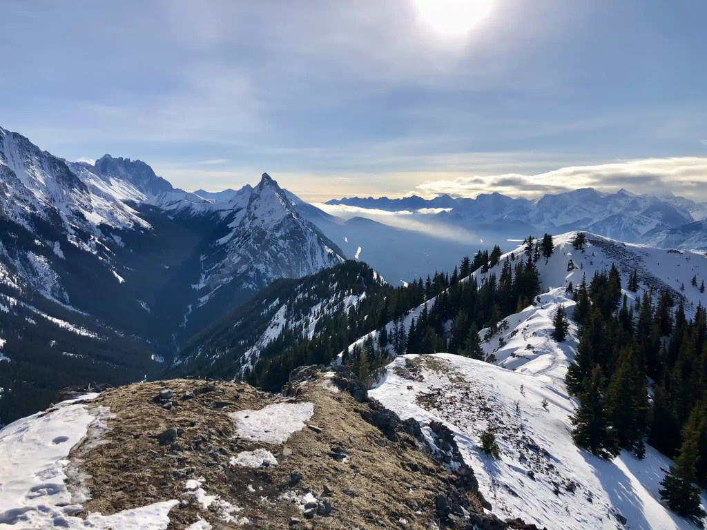
Features: King Creek Ridge features impressive views of Mount Wintour, Opal Ridge, Upper and Lower Kananaskis Lakes, and the surrounding Rocky Mountain landscape. Be ready for a steep climb up to the ridge and a moderate hike along the ridgeline. Turn around often for those sought-after and inspiring views. As a popular Kananaskis trail, hiking along the ridge is a true reward and you may cross paths with others admiring K-Country’s beauty.

King Creek Ridge Map
Finding the King Creek Ridge Trailhead

If you’re driving from Calgary, head west on the Trans Canada and take Exit 118 for Kananaskis Country. Drive south on Hwy 40 (Kananaskis Trail) until you reach the winter gate next to the turnoff for Peter Lougheed Provincial Park. The winter gate will be closed between December 1 to June 14. At the winter gate, turn left into the King Creek Day Use parking lot. Budget about 1.5 hours to drive from Calgary. Find directions to the parking area on Google Maps.
Read next: South Lawson Peak Hike in Kananaskis Country

King Creek Ridge Hike — Spectacular Hiking in Kananaskis

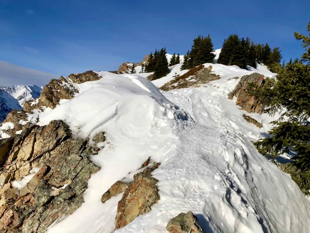
After laying up and tossing on my day pack, it was time to start the long-awaited King Creek Ridge hike. I walked north over King Creek and found the trailhead on the right-hand side (not hard to find with packed-down snow). Keep left to enter the forest. As I was expecting, the hike began in the forest and was fairly flat for a few minutes. It wasn’t long until I felt like I was climbing straight up on a snowy trail. To be fair, the hike is quite steep for most of the first two kilometres.
As you make your way up to the ridge, you’ll climb about 550 metres in the first couple of kilometres through the forest. Don’t forget to turn around to take a photo (and catch your breath). All of this effort will make reaching the ridge that much sweeter. If you’re visiting in the winter months, I highly suggest using trekking poles (any time of year, really) and trail crampons for extra traction on this steep, slippery route. You’ll finish the hard uphill slog soon enough and turn left for the ridge walk.
The hike along King Creek Ridge is a moderate rise to the summit. I stopped often for photos of the Kananaskis Lakes and Mount Wintour, offering stunning scenery on this clear day. You’ll find several lookoffs to peer down at Highway 40 — cars looking like tiny ants crawling along the route. I continued carefully along the narrow path and up the small scramble at the end. King Creek Ridge is around 8 km out and back and takes most between 4 to 6 hours (depending on your fitness and hiking pace).
Note: In the winter months, King Creek Ridge may not be the best trail for children due to the increased risk from snow cornices. Any time of the year, King Creek Ridge is a tough slog for experienced hikers or beginners looking for a new challenge. If you’re looking for an easy hike in Kananaskis, King Creek Ridge isn’t the right choice.


What To Bring — Winter Hiking in Kananaskis

If you’re not familiar with hiking in the snow, I suggest reading up on layering for winter hikes to make sure you’re prepared. Bring an insulated jacket and a rain shell to keep you warm. In my day pack, I typically carry a two-litre water reservoir and sometimes an extra water bottle (no water source on this hike). I was happy to have trail crampons and hiking poles, especially going up and down the steep sections. Of course, gloves and a toque or Buff should be part of your winter hiking kit. When hiking in bear territory, carry bear spray and know how to use it (keep it easily accessible in a bear spray holster).
Read next: 10 Day Hiking Essentials: What to Bring on a Hike
Know Before You Go

Park Pass: Visitors must purchase a Kananaskis Conservation Pass (online is easiest) before arriving at the King Creek Trailhead.
Parking: You can park at the King Creek Day Use Area near the winter gate. No additional parking fee.
Toilet: Outhouse toilets are available in the parking lot.
Garbage: If you pack it in, please pack it out. Do not leave any garbage behind (including organics, like banana peels). Practice Leave No Trace principles, such as disposing of waste properly, to help protect the natural area and wildlife.
Pets: Dogs are permitted on the trail but must remain on a leash. Please pack out your dog’s waste (you may like this smell-proof bag).
Safety: Bring a small first aid kit to deal with injuries on the trail. When I’m hiking in Kananaskis, I like to bring my Zoleo device in case of emergencies (you won’t have cell service).
Winter Safety: When hiking in Kananaskis, be sure to check Avalanche Canada forecasts and advisories before heading out.
Wildlife: Kananaskis Country is full of wildlife, including grizzlies and black bears, wolves, elk, big-horned sheep, and much more. Always maintain a healthy distance and never feed or approach wildlife. Carry bear spray and know how (and when) to use it.
Navigation: While the hiking trail is quite prominent, the lack of trail signage means you’ll need to pay attention. Bring the Gem Trek Kananaskis Lakes map and compass along. You can also download King Creek Ridge from AllTrails

More Kananaskis Winter Hikes

Are you looking for more winter hikes in Kananaskis Country? Check out these options:
- Rawson Lake Hike in Kananaskis, Alberta
- Chester Lake Hike: Winter Hiking in Kananaskis Country
- Little Lougheed Hike in Kananaskis Country
- Prairie Mountain Hike Near Bragg Creek, Alberta
- South Lawson Peak Hike in Kananaskis Country

King Creek Ridge Video
Here’s a little video to give you a sense of King Creek Ridge. What a beautiful spot!
Have you hiked King Creek Ridge in Kananaskis Country? How was your experience on this trail? Leave a comment below. Thanks for reading!
Save this for later? Hover over the image to add to Pinterest!

Thomas Coldwell has always been fond of the outdoors. He loves hiking, paddling, and camping, and thoroughly enjoys creating outdoor adventure resources for people like you. Originally from Nova Scotia, Thomas has lived in four Canadian provinces (NS, NB, ON, AB) and has travelled in 20 countries and counting.