
Do you want to go hiking near Halifax? Pennant Point Trail could be the place for you! Hike the coastal loop around Crystal Crescent Beach Provincial Park. In the summer, enjoy swimming at one of the most popular beaches in the area. In the winter months, you’ll be greeted by outstanding coastal landscapes—and possibly a trail all to yourself.

A great ending to 2022 and 2023 started off right! On New Year’s Day, I found myself in Halifax with energy (and a few extra holiday calories) to burn. After a quick search for “Halifax hikes,” I found that Pennant Point Trail consistently made the list. In the past, I’ve enjoyed day trips to Crystal Crescent Beach in the summertime, so was eager to explore more of the park. After a 30-minute drive from downtown Halifax, I made it to the trailhead and was ready for fresh air!
This post includes affiliate links. If you make a purchase through one of the links, I may receive a percentage of the sale at no extra cost to you.
About Pennant Point Trail

Location: Crystal Crescent Beach Provincial Park
Distance: 11 km loop (13 km during off-season)
Difficulty: Moderate (due to length and terrain)
Elevation: 130 metres elevation gain
Time: 3 – 4 hours
Dog-friendly: Yes, but dogs must be on a leash.
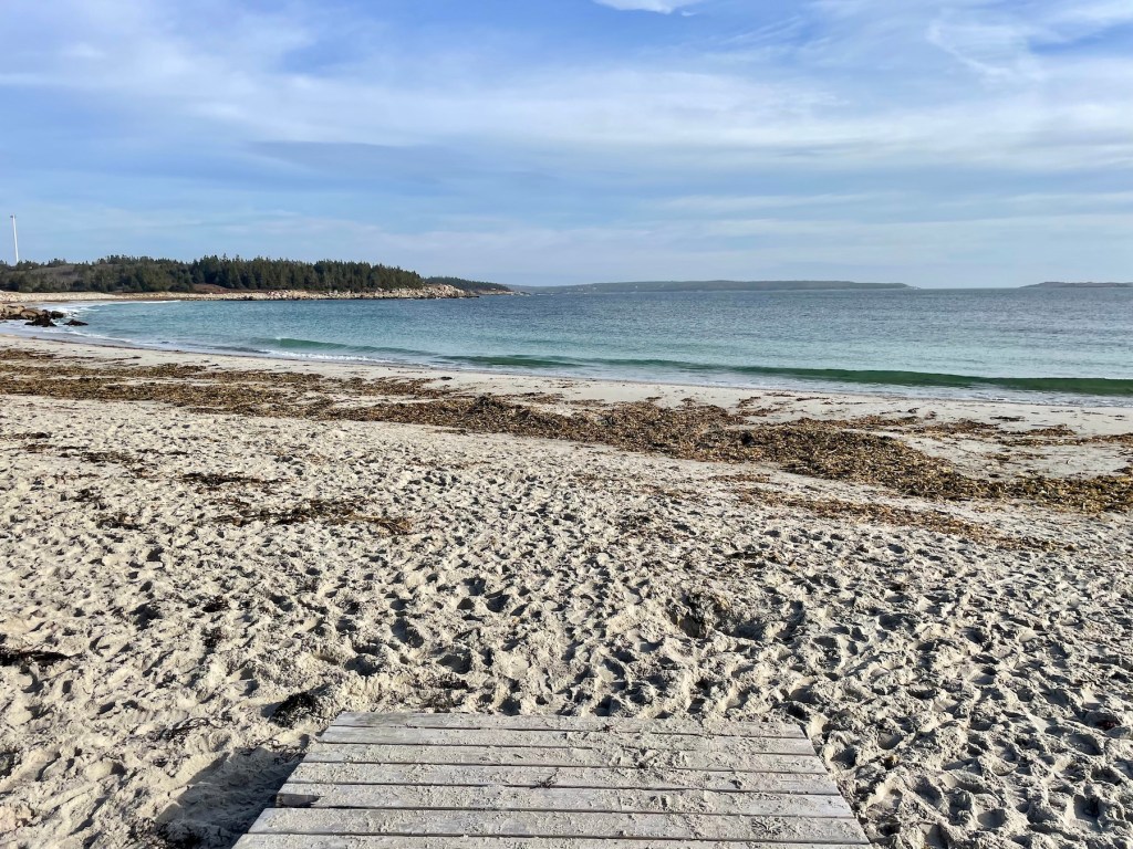
Features: Pennant Point Trail is a coastal hiking loop found 30 minutes from downtown Halifax. In the clockwise direction, the beginning of the trail includes boardwalk next to white sand beaches. Then the hiking terrain becomes more rugged. Pennant Point features stunning coastal landscape, a true escape from the hustle and bustle of city life.
Note: Crystal Crescent Beach Provincial Park is open from May 17 to Oct 14. If you visit during the off-season, the gate will be closed and you will need to add 1 km each way to reach Pennant Point Trail.

Pennant Point Trail Map
Directions to the Trailhead

After driving 30 minutes from Halifax, I was a bit discouraged to find the gate closed at Crystal Crescent Beach Provincial Park. I fully appreciate that our parks need a break, but I was really looking forward to this longer coastal hike. After some quick research, I realized that the gate closure only adds an extra 2 km out and back. Now that’s a fair trade for an empty hiking trail!
To find the trailhead, head south on Old Sambro Rd (Hwy 306) past Long Island Provincial Park. You’ll go through Spryfield, Harriestfield, and Williamswood toward Sambro. Just before Sambro, turn right onto West Pennant Rd (Hwy 349) and then turn left onto East Pennant Rd after 1.5 km. Turn left onto Sambro Creek Rd and follow until you reach Crystal Crescent Beach Rd on your right. In the summer, follow this dirt road toward the large parking area. In the off-season, park on the side of the road before the gate. You can find the destination on Google Maps.

Pennant Point Trail — Best Hiking Near Halifax

An 11-km coastal loop, Pennant Point Trail is located in Crystal Crescent Beach Provincial Park. In the off-season, add another 2 km to the overall distance due to the Crystal Crescent Beach Rd closure. After passing the beach area, I didn’t come across another soul on the entire trail. Honestly, I couldn’t have asked for a better place to end 2022.
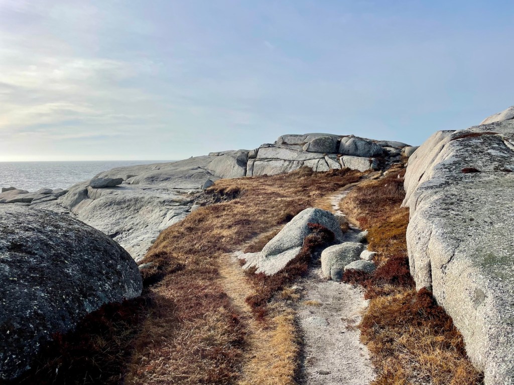
Pennant Point Trail starts on the boardwalk beside Crystal Crescent Beach, a popular white-sand beach where residents and visitors swim and soak up the sun in the summertime. After the boardwalk and well-worn dirt path, head into the forest until reaching the look-off beside Crystal Crescent Naturist Beach. Then the unmarked trail becomes more rugged and rocky, following the coastline with consistent Atlantic Ocean views. You’ll want to carry a day pack with a few essentials, like a water bottle, snacks, and other hiking essentials.
If you’re not careful, you could miss the short side trail to Pennant Point itself. You may want to use Pennant Point Trail on AllTrails to help with navigation. Then on the return half of the loop, don’t miss the right-hand turn not long after you pass the yellow bench. You’ll want to avoid the trail that continues straight toward East Pennant (there’s a log laying across it). Pennant Point Trail continues through a cleared path with dense brush on either side. By far, this was the muddiest section of the trail (wear waterproof hiking boots).
Overall, Pennant Point Trail offered exactly what I wanted in a coastal hike: groomed trails, few other hikers, and not too wet for a winter stroll. Remember, the full loop around Pennant Point Trail will typically take between 3 to 4 hours. Be prepared to hike through muddy sections in the forest and up and over large rocks.
Read next: High Head Trail: Coastal Hiking Near Halifax, Nova Scotia


What To Bring

Pennant Point Trail isn’t a short hike. You should bring essential gear to enjoy your time on the trail. First, choose a pack to hold your gear, like the Osprey HikeLite 18 (my go-to day pack!). Pack some water (I use this 2-litre water reservoir) and some high-calorie snacks like almonds or beef jerky. In Nova Scotia, you never know when it’s going to rain. Bring your rain shell along (I use the Arc’teryx Beta LT). On a breezy December day, I like to have gloves handy (like my OR Versaliner Gloves) and sturdy hiking boots for muddy trails (I use Scarpa Kailash). Always a good idea to bring a small first aid kit along, too.
Read next: 10 Day Hiking Essentials: What to Bring on a Hike

Know Before You Go

Parking: Crystal Crescent Beach Provincial Park has an official parking area near the trailhead. However, in the off-season, the provincial park’s gate remains closed. You can park before the gate on Crystal Crescent Beach Rd and walk in to the trailhead.
Toilet: You’ll find two outhouses located at the Pennant Point trailhead (near Crystal Crescent Beach). However, outhouses are not accessible in the off-season.
Dogs: You can bring your canine companion on this trail. However, remember to keep your dog on a leash in the provincial park. I also suggest carrying a smell-proof bag to pack out the dog doo!
Garbage: Remember, if you pack it in, you should pack it out (including dog poo). No garbage cans on the trail or at the trailhead in the off-season.
Signage: No signage on Pennant Point Trail after Crystal Crescent Beach. However, if you pay attention, you’ll find blue markers on rocks that can help keep you on track.
Safety: Exercise caution on this coastal trail. Remember, do not walk on the black rocks (very slippery) or too close to the cliff’s edge. Atlantic Ocean waves are strong and powerful; an accident could be fatal.


Outdoor Hiking Etiquette

I must say, Pennant Point Trail is a beautiful place to spend the day. For nearby residents or visitors from away, I would recommend visiting Crystal Crescent Beach Provincial Park!
After finishing my hike, I walked back toward my car on Crystal Crescent Beach Rd. As I passed the gate, I noticed piles of full dog bags tossed in front of a sign that reads: “Help preserve the environment. Leave no trace. Pack it in, pack it out.” To say nothing of the irony, “pack it out” doesn’t mean leaving litter at the trailhead (or the gate). Remember to take your garbage home (including pet waste) and dispose of it properly. Bring a smell-proof bag to pack out your pup’s business.
If you’re not already familiar, explore Leave No Trace Principles and practice them during your outdoor adventures. Let’s do what we can to minimize our impact on the environment. As nature enthusiasts, and as a species dependent on nature, we want to do what we can to protect and preserve provincial parks (and other wilderness areas) for future use.
Read next: How To Make Your Outdoor Adventures More Sustainable

Have you hiked Point Pennant Trail? Any other hiking trails near Halifax that you enjoy? Let me know in the comments below!
Save this for later? Hover over the image to add to Pinterest!

Thomas Coldwell has always been fond of the outdoors. He loves hiking, paddling, and camping, and thoroughly enjoys creating outdoor adventure resources for people like you. Originally from Nova Scotia, Thomas has lived in four Canadian provinces (NS, NB, ON, AB) and has travelled in 20 countries and counting.


I did the eastern half today barefoot, which is good because of the muddy areas, but I think I mssed pennant point itself. Wish there were more barefoot hikers. I got to the happy face marker but not the yellow bench. Is the pennant point offshoot further or did I miss it?
Hi John, thanks for your comment. Glad you enjoyed the trail barefoot! There is a short offshoot that goes to the ‘point’ (see map). Happy trails!