
Hiking the West Coast Trail on Vancouver Island is one of the most thrilling outdoor adventures in Canada, and it takes serious planning to do it right. Once our 2021 permits were secured, I spent hours researching the route and preparing for the challenges ahead. If you’re planning to hike the West Coast Trail for the first time, this guide will walk you through everything you need to know, from reservations and transportation to weather, tides, and what to pack. Let’s get you ready to step onto the trail feeling confident and prepared.

Last Updated: January 20, 2026
Hiking the West Coast Trail is considered one of Canada’s top multi-day backpacking experiences. My friend Kevin and I were lucky to secure mid-July permits, and I planned the trip from start to finish. This guide covers everything you need to plan your first West Coast Trail hike, including logistics, safety considerations, and realistic expectations. If you still have questions after reading, feel free to reach out. I’m always happy to help.
This post includes affiliate links. If you make a purchase through one of the links, I may receive a percentage of the sale at no extra cost to you.
West Coast Trail Map
I created a digital West Coast Trail map showing approximate campground locations and points of interest. That being said, the official Parks Canada West Coast Trail mapis essential, especially for beach access points and tide-dependent sections. You’ll receive a printed map during the mandatory orientation, and I strongly recommend carrying it with you while hiking the West Coast Trail.
About the West Coast Trail

Location: Pacific Rim National Park Reserve, Vancouver Island, British Columbia
Distance: 75 km point to point
Difficulty: Difficult
Elevation gain: ~230 metres at the steepest point
Time: 7 days / 6 nights
Dog-friendly: No, only service animals are permitted
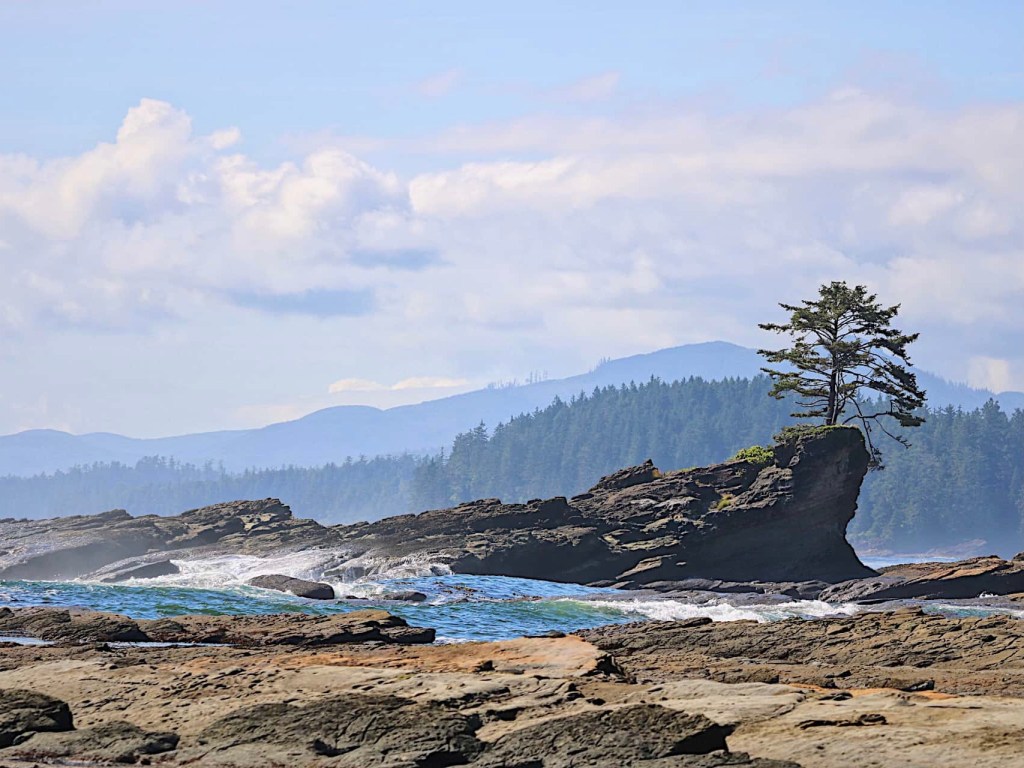
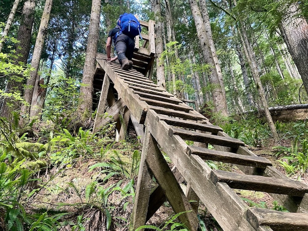
Features: The West Coast Trail is a spectacular coastal route with well-maintained campgrounds spaced along the way. Hikers are rewarded with dramatic ocean views, frequent wildlife sightings, and historic lighthouses at Pachena Bay and Carmanah Point. That being said, this trail earns its reputation. Hiking the West Coast Trail is highly technical, with more than 100 ladders, slick boardwalks, roughly 130 bridges, frequent river crossings, and four cable cars. Come prepared, watch your footing, and give yourself plenty of time.
2026 Season Update: West Coast Trail reservations will launch on February 5, 2026 at 8am PT.

West Coast Trail FAQs

Q. Where is the West Coast Trail located?
A. The West Coast Trail is located in Pacific Rim National Park Reserve on Vancouver Island, British Columbia, within the traditional territory of the Huuay-aht, Ditidaht, and Pacheedaht First Nations.
Q. How long is the West Coast Trail?
A. The official distance is 75 kilometres point to point, though some hikers record closer to 85 kilometres due to beach routes, campsites, and side trips.
Q. How difficult is hiking the West Coast Trail?
A. This is a very technical hike. While some sections feel more manageable, the combination of ladders, mud, tides, weather, and long days makes the West Coast Trail an advanced backpacking experience overall.
Q. Do you need a reservation to hike the West Coast Trail?
A. Yes. West Coast Trail reservations are mandatory, and permits are limited each day. You must book in advance through Parks Canada.
Q, How long does it take to hike the West Coast Trail?
A. Most hikers complete the trail in 6 to 8 days. A 7-day itinerary is the most common and works well for first-timers (that’s what we did, and I loved it).
Q. Is the West Coast Trail dog-friendly?
A. No. Dogs are not permitted on the West Coast Trail unless they are registered service animals.
Q. Do you need experience to hike the West Coast Trail?
A. Yes. This trail is not recommended for beginner backpackers. Prior experience with multi-day hikes and carrying a heavy pack is strongly advised.
Q. Is the West Coast Trail dangerous?
A. It can be. Hazards include slippery boardwalks, ladders, river crossings, tides, and changing weather. Most incidents are caused by slips and falls.
Q. Can you hike the West Coast Trail solo?
A. Solo hiking is allowed, but it’s more common (and safer) to hike with a partner or group, especially given the trail’s technical nature and remoteness.
Q. Is there cell service on the West Coast Trail?
A. No. Cell service is extremely limited to nonexistent. Many hikers carry a satellite communicator for emergencies.
Is Hiking the West Coast Trail for You?

Now it’s time to decide: Is hiking the West Coast Trail right for you? In some cases, the bigger question is whether this is the right time to take on the trail. Parks Canada offers a helpful self-assessment to determine if this hike is a good fit for your experience and skill level. The physical and mental demands of the West Coast Trail shouldn’t be underestimated. This is a highly technical hike and it’s not for everyone. I wouldn’t recommend it for new backpackers, as the risks can add up quickly. That being said, if you’ve enjoyed multi-day hikes before and are reasonably fit, the West Coast Trail can be an incredibly rewarding challenge.
West Coast Trail hiking is for people who are:
- Experienced with multi-day overnight backpacking
- Comfortable hiking long distances through challenging terrain with a heavy pack
- Flexible and willing to adjust plans based on weather, tides, and trail conditions
Read next: The West Coast Trail: 7 Days on BC’s Most Popular Trek
History of the West Coast Trail

The West Coast Trail is a 75-kilometre, multi-day backpacking route located within Pacific Rim National Park Reserve, passing through the traditional territory of the Huuay-aht, Ditidaht, and Pacheedaht First Nations. These Nations have lived on Vancouver Island since time immemorial.
Indigenous communities originally established these coastal walking and paddling routes, which were later used to rescue shipwreck survivors from the Juan de Fuca Strait. Over time, sailors came to refer to this dangerous stretch of coastline as the “Graveyard of the Pacific.” In response to frequent shipwrecks and growing public concern, the Pachena and Carmanah lighthouses were built to improve marine safety. In 1973, the West Coast Trail officially became part of Pacific Rim National Park.
Today, the West Coast Trail is managed in partnership with Parks Canada and the Huuay-aht, Ditidaht, and Pacheedaht First Nations. More than 7,500 people hike the trail each year. As visitors, it’s important to respect the land and the Indigenous communities who steward and share this remarkable place.

Best Time to Hike the West Coast Trail (Weather & Conditions)

The West Coast Trail is typically open from May 1 to September 30 each year. It’s worth noting that opening dates can vary depending on conditions. The best time to hike the West Coast Trail is somewhat subjective, but July and August are the most popular months thanks to generally warmer, drier weather. We started our hike in mid-July and experienced just one day of rain, which made for excellent hiking conditions!
The trail receives an average of about 330 cm of rain annually, with the heaviest rainfall typically occurring in May and June. Fog is more common in July and August, especially along coastal sections. Average summer temperatures hover around 14°C, with daytime highs occasionally reaching 20°C on clear days.
Read next: Your Complete Guide to the Bowron Lake Canoe Circuit

West Coast Trail Reservations: How to Book the West Coast Trail

Reservations are mandatory for the West Coast Trail. A total of 70 hikers are permitted to start the trail each day: 25 from Pachena Bay, 25 from Gordon River, and 20 from Nitinaht Narrows. You can book online at reservation.pc.gc.ca or by calling 1-877-RESERVE (1-877-737-3783). When booking, you’re reserving a date range, not individual campsites. Campsites are first come, first served along the trail.
A quick heads-up: West Coast Trail reservations are highly competitive. Permits often sell out quickly when reservations open, typically in January for the May to September hiking season. Midweek start dates and shoulder months like June or September often have better availability, though weather can be less predictable. If you don’t secure your preferred dates right away, check back. Cancellations do happen. Just note that the standby option was removed in 2018, so you can’t arrive at the trailhead without a valid reservation.
Tip: Create your Parks Canada account well before reservations open. When booking day arrives, using both the online system and the phone line can improve your chances of securing a permit.

How Much Does It Cost to Hike the West Coast Trail?

The West Coast Trail is not an inexpensive adventure. Depending on where you’re travelling from, additional costs, such as flights, accommodations, and meals before or after the hike may also factor into your budget. Below is a basic fee breakdown for West Coast Trail hikers:
| Reservation fee | $25.75 |
| West Coast Trail permit / overnight use fee: | $166.75 |
| Ferry crossing fees (Gordon River + Nitinaht Narrows) | $28 |
| National Park Entry Fee Parks Canada Discovery Pass | $11/person/day $145.25 for up to 7 people |
| West Coast Trail Express or other shuttle | ~$95+ |
A common estimate for a 7-day West Coast Trail hike is approximately $325–$410 per person before travel and food costs, depending on ferry and shuttle choices.

Where To Stay in Victoria (Before & After Your Hike)

If you’re travelling from out of town, staying a night in Victoria is a great option before starting the West Coast Trail. We flew in and stayed downtown the night before our early shuttle pickup, which made for a smooth and low-stress start.
Victoria offers a wide range of accommodation options, from budget-friendly hostels to mid-range and higher-end hotels. For budget travellers, Ocean Island Inn is a popular choice among hikers. It’s centrally located and within walking distance of the shuttle pickup, making it a practical option both before and after your hike.

Transportation to the West Coast Trail

Once your permits and flights are booked, you’ll need to arrange transportation to the trailheads. Most hikers use the West Coast Trail Express shuttle, which offers reliable service between Victoria, Port Renfrew, and Bamfield. We were picked up from Capital City Station at 6:30am, making for a straightforward and stress-free start to the hike.
If you’re travelling with your own vehicle, you can also drive to either Port Renfrew or Bamfield, leave your car there, and shuttle to the opposite trailhead. This option works well if you want your vehicle waiting for you at the end of the trail.
Read next: Nairn Falls Hike Near Whistler, British Columbia

Mandatory West Coast Trail Orientation

Mandatory orientation sessions are provided by Parks Canada staff at Pachena Bay and Gordon River before starting the West Coast Trail. In most years, orientations are held at set times, typically around 10am and 2pm. However, schedules can change. During our visit, orientations were staggered as groups arrived throughout the day, and hikers were required to watch a short video presentation before arrival.
During orientation, Parks Canada staff share important updates on current trail conditions, wildlife activity, and other essential safety information. To check in at the trailhead and receive your trail permit, you’ll need a copy of your reservation that includes the reservation code. I printed mine and brought a paper copy, but a screenshot would work, too (remember, limited to no cell service).

Ferry Schedules

There are two ferry crossings on the West Coast Trail: Nitinaht Narrows (KM 32) and Gordon River (KM 75). Both crossings operate during the hiking season, but schedules can vary slightly each year and are subject to weather and staffing. In general, ferry service runs during daytime hours, with crossings typically available from morning through mid-to-late afternoon. At Gordon River, hikers signal the operator using the buoy beside the ladder, while crossings at Nitinaht Narrows are handled by a local water taxi service.
If you’re starting or ending your hike at Nitinaht Narrows, you’ll also need to plan around the scheduled water taxi to and from Nitinaht Village, which usually runs once daily in each direction. Exact departure times are provided during the mandatory orientation, and it’s important to build ferry timing into your daily plans. Confirm current schedules with Parks Canada or local operators before starting your hike.
Read next: Your Complete Guide to Hiking in Tombstone Territorial Park

Distances on the West Coast Trail

| KM | Location | Notes |
|---|---|---|
| 0 | Pachena Bay Trailhead | Main northern trailhead. Orientation, toilets, and clear signage. Good place for last-minute gear checks. |
| 9 | Sea Lion Haul Out Rock | Active sea lion colony. Very loud. Observe from a distance. |
| 9.5 | Pachena Point Lighthouse | Historic lighthouse with great views. Snacks sometimes available. |
| 12 | Michigan Creek Campground | Popular first-night stop. Sheltered, good tent sites, reliable water. |
| 13.7 | Darling River Campground | Quieter alternative to Michigan Creek. Good if you push a little farther. |
| 15 | Orange Juice Creek Campground | No composting toilet. Often skipped, but useful as a backup. |
| 16.5 | Tsocowis Creek Campground | Less crowded. Decent tenting and water access. |
| 18 | Valencia Bluffs Viewpoint | Major scenic highlight. One of the best viewpoints on the trail. |
| 23 | Klanawa River Campground | Wide river crossing. Check water levels before committing. |
| 25 | Tsusiat Falls Campground | Iconic waterfall campsite. Very popular (arrive early). |
| 32.2 | Nitinaht Narrows & Crab Shack | Mid-trail resupply and food stop. Check ferry and water taxi schedules. |
| 41.5 | Cribs Creek Campground | Spacious campground near the beach. Good midpoint option. |
| 44 | Carmanah Point Lighthouse | Remote lighthouse with dramatic coastal views. |
| 46 | Carmanah Creek Campground | Sheltered forest camping. Reliable freshwater nearby. |
| 47 | Chez Monique’s Restaurant | Famous burger stop. Hours and availability vary. |
| 48 | Bonilla Creek Campground | Good tent sites and water access. Often less crowded. |
| 53 | Walbran Creek Campground | Large river crossing. Can be challenging after heavy rain. |
| 56 | Logan Creek Suspension Bridge | Longest suspension bridge on the trail. Slow and steady. |
| 57.7 | Cullite Cove Campground | Smaller, more exposed campsite. Can be windy. |
| 62.2 | Camper Bay Campground | Good staging point for Owen Point tide window. |
| 67 | Owen Point | Must-see headland. Tide-dependent (plan carefully). |
| 70 | Thrasher Cove Campground | Steep ladders in and out. Often used before final day. |
| 75 | Gordon River Ferry | Southern exit point. Ferry schedule is critical. |

7-Day West Coast Trail Itinerary (+ More Options!)

There are several West Coast Trail itinerary options, but most hikers complete the trail over 7 days and 6 nights, and our trip was no exception. Faster backpackers may finish in less time, while others choose to add extra days to move at a slower pace. It’s also possible to start at Nitinaht Narrows and hike either north to Pachena Bay or south to Gordon River.
Below is the most common 7-day West Coast Trail itinerary and the route we followed:
Day 1: Pachena Bay to Michigan Creek (KM 0–12)
Day 2: Michigan Creek to Tsusiat Falls (KM 12–25)
Day 3: Tsusiat Falls to Cribs Creek (KM 25–41.5)
Day 4: Cribs Creek to Walbran Creek (KM 41.5–53)
Day 5: Walbran Creek to Camper Bay (KM 53–62)
Day 6: Camper Bay to Thrasher Cove (KM 62–70)
Day 7: Thrasher Cove to Gordon River (KM 70–75)
Depending on your schedule and fitness level, you may want to adjust this plan. Many hikers skip Thrasher Cove for a 6-day itinerary, while others add extra nights for a more relaxed pace. Campgrounds like Orange Juice Creek (KM 15), Klanawa River (KM 23), Carmanah Creek (KM 46), and Bonilla Creek (KM 48) are often less busy and can offer a quieter experience.
Whatever route you choose, the West Coast Trail offers 13 official campgrounds, giving you plenty of flexibility to tailor the hike to your preferences.

Comfort Camping Options on the West Coast Trail

Update: The Ditidaht First Nation comfort camping options at Tsquadra Point are no longer operating and are not available to book.
However, hikers still have the option to stay in reservable cabins at Nitinaht Narrows, located at the midpoint of the West Coast Trail. These cabins are operated by Nitinat Wilderness Charters and offer a more comfortable alternative to tent camping. Cabins typically sleep between 1 and 8 people, with rates starting around $150 per night, though prices and amenities can vary. Reservations are recommended and can be made directly through Nitinat Wilderness Charters.
Note: Staying at Nitinaht Narrows can be a welcome break in the middle of your hike, especially if you’re looking to dry out, enjoy a hot meal, or take a brief rest from tent camping.

Safety on the West Coast Trail

Staying safe on the West Coast Trail requires a clear understanding of the risks. Hazards include surge channels, impassable headlands, rotting boardwalks, and slippery beach shelves (many of which are marked on the Parks Canada WCT map). When conditions are poor, slow down and move deliberately. Most emergency evacuations are caused by slips and falls on rocks, ladders, boardwalks, and roots.
Small earthquakes occur regularly along the west coast. While tsunamis are unlikely, escape route signs are posted throughout the trail. If you feel the ground shake or see the ocean suddenly recede, move to higher ground without abandoning your pack.
Carry a first aid kit and consider wilderness first aid training before hiking the trail. My first aid use was mostly preventative. Daily Leukotape kept blistering to a minimum (the best!). Trekking poles and supportive hiking boots also made a big difference.
Before you go, leave a detailed trip plan with someone at home, including your itinerary and expected return date. In an emergency, this information can be critical.
Note: More than 100 emergency evacuations occur on the West Coast Trail each season. In an emergency, call 1-877-852-3100 or contact a ferry operator, lighthouse staff, Parks Canada staff, or a trail guardian to request an evacuation. Do not call 911. Emergency evacuations are included in the WCT fee, so there is no additional cost. Evacuations can take up to 24 hours, depending on conditions. Never leave an injured member of your group alone.

Navigating Tides on the WCT
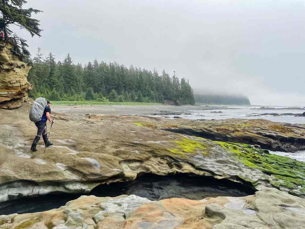
Navigating the tides is essential when hiking the West Coast Trail. Several beach sections are impassable at high tide, so timing matters. You’ll receive a high and low tide schedule during orientation, but it requires adjusting for daylight saving time. I found it much easier to bring a Tofino tide table, which shows hourly tide levels for each day and is already adjusted. I highly recommend carrying a copy with you.

One of the most well-known tide-dependent sections is Owen Point, near Thrasher Cove. It’s absolutely worth the effort to plan for. This headland is only passable when tides are below 6 feet (1.8 metres). On our hike, the best window was roughly between 8am and 1pm. I suggest using the tide table alongside the tide information on the Parks Canada WCT map to determine when beach routes are safe to travel.
Note: Bring a Tofino tide table with you. It’s far more useful than relying on daily high and low tides alone, especially if you plan to take the beach routes whenever possible. While some forest sections have no alternative, the long stretches of beach are what make the WCT truly spectacular. Effective tide planning lets you enjoy them safely.

Wildlife on the West Coast Trail

The West Coast Trail is full of wildlife, including black bears, cougars, wolves, sea lions, and plenty of birds. One of my favourite moments was watching an eagle eat a fish on a piece of driftwood, and we also spotted a black bear feeding along the beach. Encounters like these are part of what makes the trail so special, but they also come with responsibility.
Stay aware of your surroundings and give wildlife plenty of space. Never approach or feed wild animals, keep campsites clean, and use food lockers (never store food in your tent). Stick together as a group and don’t leave children unsupervised. If you do encounter a predator, back away slowly while facing the animal and make sure it has room to retreat. If the situation escalates, make yourself appear larger. Never run and never play dead.
Most wildlife encounters on the West Coast Trail are calm and happen at a respectful distance. With a bit of awareness and preparation, hikers and wildlife generally coexist without issue. That’s exactly how it should be.
Read next: Your Complete Guide To Hiking North/South Kananaskis Pass

Eating on the West Coast Trail

Whether at home or on the trail, meal planning has never been my favourite part of a trip. Unsurprisingly, I’ve come to appreciate freeze-dried meals from Backpacker Pantry and AlpineAire mostly. Some are definitely better than others, but I value the convenience and packability and am usually willing to pay for it. That being said, I know there are plenty of people making genuinely great food in the backcountry (and I admire you). If you have easy, foolproof meal ideas, I’d love to hear them!
Here’s what I brought for 7 days / 6 nights on the West Coast Trail:
- Instant oatmeal (16 packets; 4 per breakfast)
- Instant mashed potatoes (3 packets — surprisingly great as breakfast)
- Peanut butter (small plastic jar)
- Tortilla wraps (large package, shared)
- Sidekicks (3 packets)
- Soup (3 packets)
- Freeze-dried meals (8 total, including one extra)
- Almonds and cashews
- Tea
- Chocolate bars
- Candy
If you’d rather eat something fresh, there are two food stops along the trail. Carl’s Crab Shack at Nitinaht Narrows is a popular lunch stop, serving freshly-caught crab, salmon, potatoes, grilled cheese, and more. Nytom Burger Shack, which replaced Chez Monique’s near Carmanah Creek, is a burger stop farther south.
At camp, always store food in the food lockers and never leave it unattended. If lockers are full, hang your food in a dry bag about 4 metres off the ground and 3 metres from the tree trunk. Never keep food or other attractants in your tent.
Each campground has a freshwater source nearby, and there are additional water sources along the trail. However, there can be long stretches without easy access (especially in drier conditions) so plan ahead and carry a reliable water filtration system (I used the MSR Trailshot… worked great!).

Poopin’ on the WCT (What You Need to Know)

So, where does one do their business on the trail? Fortunately, there are composting toilets at most campgrounds along the West Coast Trail. Practice good backpacker etiquette when using them: keep things tidy and always close the lid. If you want to see exact toilet locations, check out the WCT map above. Toilets are available at every campground except Orange Juice Creek, and there are public washrooms at Pachena Bay and Gordon River. There are no public toilets at the Pachena or Carmanah lighthouses.
If there’s no toilet nearby, it’s time to dig a hole. Human waste should be buried in a 20 cm (7 inch) hole at least 30 metres (100 feet) from waterways, campsites, and trails. Toilet paper can be deposited in the next outhouse or burned if conditions allow, but personal hygiene products must always be packed out.
Read next: 11 Top Backpacking Trips in Canada For Your List

West Coast Trail Packing List (What to Bring Hiking)

In many ways, putting together your West Coast Trail packing list comes down to personal preference. Ultralight hikers will aim to trim every ounce, while others may choose to bring a few comfort items for the backcountry. A good rule of thumb is to keep your fully loaded pack to no more than 20 percent of your body weight.
Here’s what I packed:
- Osprey Kestrel 68
- Waterproof pack cover
- Tent
- Sleeping bag
- Therm-a-rest NeoAir
- Sleeping bag liner
- Siltarp
- Camp shoes
- Scarpa hiking boots
- Arc’teryx Beta LT rain shell
- Rain pants
- OR Rocky Mountain High Gaiters
- Jetboil Flash & fuel
- Campsuds soap
- Osprey 2L reservoir
- Nalgene water bottle
- Hiking poles
- Lighter / matches
- GSI mug
- Spoon
- Sunscreen
- Sunglasses
- Bug spray
- Toilet paper
- Towel
- Toothbrush / toothpaste
- MSR TrailShot filter
- Headlamp
- Paracord
- Buff
- Mora Knife
- First aid kit
- ENO Hammock
- 3 merino wool t-shirts
- 1 long sleeve (love this Patagonia Capilene)
- 2 pair of pants
- 2 pairs of shorts
- 1 merino leggings (for sleeping)
- 3–4 pairs of merino underwear
- 3 – 4 pairs of merino wool socks
- Warm jacket (love this Patagonia down sweater jacket)
- Fleece sweater
- Winter hat / gloves
- Map / compass
- Satellite comms (Zoleo)
- Powerbank
- Cameras
- Food
- Bear spray
- Wallet (+ ID)
- Parks Canada pass
- Tofino tide table
- Reservation copy
- Cash (for food)
- Change of clothes for the end
Next time, I’d leave a few things behind. I wouldn’t bring my hammock (we slept on the beach), I didn’t need the extra pot (I’d just use the Jetboil). I’d also simplify my clothing: 2 merino t-shirts, 1 long-sleeve, 1 pair of pants, 1 pair of shorts, 2 pairs of merino underwear, 3 pairs of merino socks, 1 down jacket, and 1 fleece sweater.
I also packed more food than I needed (which is always better than the alternative!), but with a bit more planning, it would’ve been easy to shave some extra weight. Strategic food packing can make a noticeable difference over the course of the WCT.
Note: If you’re flying in from another city or province, you won’t be able to bring stove fuel or bear spray on the plane. Plan to purchase these after you arrive. Downtown Victoria has several outdoor stores, including MEC and Valhalla Pure Outfitters, where you can pick up last-minute supplies before heading to the trail.

WCT Rules & Regulations

These are the official Parks Canada rules for hiking the West Coast Trail:
Respect: Be considerate of fellow hikers to help ensure a safe and enjoyable experience for everyone.
Cultural and Natural Resources: The Canada National Parks Act prohibits removing or damaging natural and cultural resources, including marine life, shells, fossils, and plants. Removing man-made debris (such as buoys) is permitted.
Leave No Trace: If you pack it in, pack it out. This includes food waste, packaging, and wet or soiled gear. Brush up on Leave No Trace principles before heading out.
Fires: Use a stove whenever possible. If fires are allowed, use only small pieces of driftwood below the high-tide line. Fires are not permitted in the forest.
Camping: Camp only in designated beach sites and do your best to protect the sensitive forest environment.
Water: Do not contaminate freshwater sources. Wash dishes and bathe in the ocean only.
First Nations Reserves and Private Property: Stay on the main trail and respect First Nations reserves, Guardian cabins, lighthouse grounds, and all people and places along the route.

Video: Hiking the West Coast Trail on Vancouver Island
More WCT Resources

There are plenty of useful resources available for first-time hikers on the West Coast Trail. Before our trip, I read several blog posts from experienced adventure bloggers, including Your Guide to the West Coast Trail in British Columbia from Happiest Outdoors and West Coast Trail: What You Need to Know from my friend Leigh at HikeBikeTravel.
There’s also a well-known guidebook, Blisters and Bliss: A Trekker’s Guide to the West Coast Trail, which many hikers rely on when planning their trip. And, of course, Parks Canada’s official West Coast Trail Hiker Preparation Guide is an essential resource for up-to-date trail information and safety guidance.

Getting ready for the West Coast Trail? Did you find this guide useful? Is there anything else you’d like to know? Leave a comment below!
Save this for later? Hover over the image to add to Pinterest 👇

Thomas Coldwell has always been fond of the outdoors. He loves hiking, paddling, and camping, and thoroughly enjoys creating outdoor adventure resources for people like you. Originally from Nova Scotia, Thomas has lived in four Canadian provinces (NS, NB, ON, AB) and has travelled in 20 countries and counting.


Thank you for sharing your West Coast Trail Guide!! Loved reading this in preparing for my hike later this year!! ❤️🥾🏕
Thanks, Marie-Andree! I’m glad you’ve found this guide helpful and I hope you have a great WCT experience. It’s such an incredible adventure!
I did the WCT last summer and would
Like to commend you on your thoroughness!! I also used the hourly tide chart ( best advice )
Thanks, Nikki!! Glad you had the chance to experience the WCT. I really wanted to make this guide as detailed as possible (without being too much). Appreciate your feedback! Yes, the hourly tide chart was invaluable — completely agree.
Thanks for writing this – very helpful info! 🙂
Glad you found it useful!!
Incredible detail, thank you for sharing your knowledge.
I am extremely hopeful to experience the WCT, I have had a hip replacement at 51 ( an auto immune disorder that attacks my joints) and they want to replace the other side later this year. So I’m hiking as much as possible in and around Kelowna this year to get myself conditioned enough to tackle this great adventure. Watching your video has shown me what I would miss if I don’t conquer it!
🪂🥾🧗where there is a will, there is a way!
Thank you so much !
~Andrea/Kelowna BC
Hi Andrea, thanks for your message! I’m glad you found my guide and video helpful. All the best as you train and prepare — the WCT is an incredible journey, for sure!